
What is GPR?
Ground Penetrating Radar (GPR) is an Ultra Wide Band (UWB) pulse-based technology that locates objects buried underground. It is used to locate underground utilities, underground storage tanks, pipes, crevices, burials, memorials, and conduits. Additionally, GPR surveys are used during concrete inspections and utility locating to determine the structural integrity of the ground underneath a road or runway.
Ground Penetrating Radar Surveys
Ground Penetrating Radar surveys are a geophysical method of non-destructive testing that uses high or low-frequency radio signals, between 1 to 1000 MHz depending on the scale and conditions of the project, that are transmitted into the ground. These signals, or pulses, are reflected back to the receiver by metallic and non-metallic objects located belowground. This information is stored on digital media. A radar unit will emit a pulse and receive the reflected signals up to one thousand times per second.
In a sentence, Ground Penetrating Radar is a method of viewing buried infrastructure or objects located underground, without digging.
GPR Explanations
A Ground Penetrating Radar system uses an antenna to emit radio waves into the ground. The GPR system’s control unit will then measure the time it takes for the signal to travel to and return from the object to determine its depth and position. As waves bounce off buried objects, the antenna records the strength and travel time it takes for the wave to bounce back to the receiver. When the GPR signal hits an object with different properties than the material surrounding it, it produces a reflection.
How does GPR work?
The amplitude or strength of the reflection is based on the difference in electrical conductivity and dielectric permittivity of the two materials. Reflections are recorded as radar signal waves that are emitted in a cone shape, not a straight line.
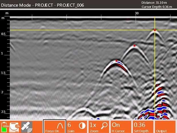
This results in an object being recorded as a hyperbola, or inverted U shape on the receiver screen. The object is actually located at the peak amplitude of the hyperbola. The higher the frequency of the antenna, the shallower into the ground it will penetrate. A higher frequency antenna will also “see” smaller targets.
GPR Data Processing
The field GPR technician will review and interpret the GPR data obtained during the survey. When the signal is reflected off of a buried object the screen will show a hyperbola. This information is displayed by the system’s viewing screen, allowing the field operator to provide on-site GPR interpretation as well as storing the GPR records for future use.
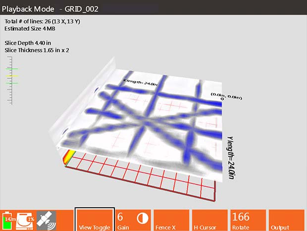
Some clients require a more detailed 3D Ground Penetrating Radar survey that is designed and processed by specialized computer software. The 3D GPR method allows for an extensively detailed depth slice that allows technicians to more accurately map an area.

Our GPR Equipment
Omega Mapping Services uses the Geophysical Survey Systems International (GSSI) SIR 4000 systems. These top-of-the-line systems may use either a digital and/or an analog antenna. Weighing in at 10 pounds, the system is nimble enough to use for large jobs which take an extended period of time. The GSSI SIR 4000 system allows in-field data interpretation with a high-resolution viewing screen, which saves time for both the technician and the client.
GPR Limitations
The Ground Penetrating Radar’s pulses, or waves, will need to travel through a variety of substrate materials such as soil, concrete, fill material, and debris – all of which will have varying levels of water saturation and differing electrical properties. Highly conductive materials, such as salt-rich or clay soil, prove to be the most challenging substrates to work with.
Performance can also be also limited by signal scattering commonly seen in rocky soil. Additionally, the fact that the Ground Penetrating Radar system is pushed or pulled along the ground surface makes it difficult to collect data in areas with ground obstructions such as a pipe running along a curb.